
Thank you for supporting this site ❤️
Make a donation
Make a donation
Schönbrunn topographic map
Click on the map to display elevation.
Thank you for supporting this site ❤️
Make a donation
Make a donation
Schönbrunn
Schönbrunn liegt nordwestlich der Stadt Lengenfeld im Osten des Naturraumes Vogtland sowie im sächsischen Teil des historischen Vogtlands. Der Ort befindet sich in einer Höhe von ca. 370 m NHN im Göltzschtal. Die Dorfflur umfasst etwa 980 Hektar.
Thank you for supporting this site ❤️
Make a donation
Make a donation
About this map
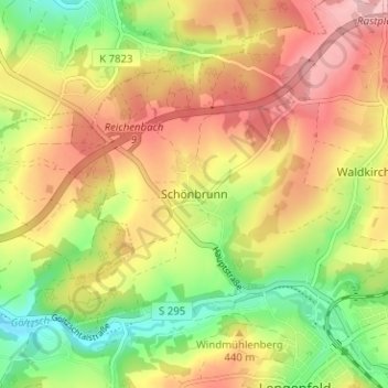
Name: Schönbrunn topographic map, elevation, terrain.
Average elevation: 423 m
Minimum elevation: 344 m
Maximum elevation: 496 m
Thank you for supporting this site ❤️
Make a donation
Make a donation