
Make a donation
Omaha topographic map
Click on the map to display elevation.
Make a donation
Omaha
Omaha features a varied topography characterized by rolling hills and valleys that rise gently from the Missouri River, which forms the city's eastern boundary. The landscape is primarily composed of prairie and hardwood forests, offering a mix of open spaces and wooded areas. Elevations within the city range from approximately 900 to 1,300 feet above sea level, creating a scenic backdrop that includes prominent bluffs overlooking the river. This diverse terrain not only enhances the aesthetic appeal of the city but also contributes to its recreational opportunities, with parks and trails that take advantage of the natural contours and vistas. The area's fertile soil supports agriculture in the surrounding regions, further shaping the economic and cultural identity of Omaha.
Make a donation
About this map
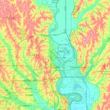
Name: Omaha topographic map, elevation, terrain.
Location: Omaha, Douglas County, Nebraska, United States (41.19059 -96.26820 41.39306 -95.87114)
Average elevation: 338 m
Minimum elevation: 291 m
Maximum elevation: 413 m
Make a donation
Other topographic maps
Click on a map to view its topography, its elevation and its terrain.