
Thank you for supporting this site ❤️
Make a donation
Make a donation
Cimanuk topographic map
Click on the map to display elevation.
Thank you for supporting this site ❤️
Make a donation
Make a donation
About this map
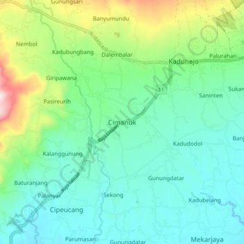
Name: Cimanuk topographic map, elevation, terrain.
Location: Cimanuk, Pandeglang, Banten, Java, 42271, Indonesia (-6.39227 105.99741 -6.31227 106.07741)
Average elevation: 232 m
Minimum elevation: 98 m
Maximum elevation: 644 m
Thank you for supporting this site ❤️
Make a donation
Make a donation
Other topographic maps
Click on a map to view its topography, its elevation and its terrain.