
Thank you for supporting this site ❤️
Make a donation
Make a donation
Port Heights topographic map
Click on the map to display elevation.
Thank you for supporting this site ❤️
Make a donation
Make a donation
About this map
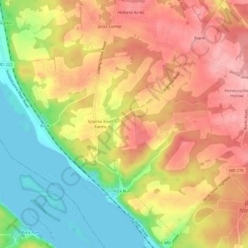
Name: Port Heights topographic map, elevation, terrain.
Location: Port Heights, Cecil County, Maryland, 21094, United States (39.60567 -76.14328 39.64567 -76.10328)
Average elevation: 69 m
Minimum elevation: 0 m
Maximum elevation: 126 m
Thank you for supporting this site ❤️
Make a donation
Make a donation
Other topographic maps
Click on a map to view its topography, its elevation and its terrain.