
Thank you for supporting this site ❤️
Make a donation
Make a donation
Sollerön topographic map
Click on the map to display elevation.
Thank you for supporting this site ❤️
Make a donation
Make a donation
About this map
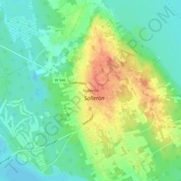
Name: Sollerön topographic map, elevation, terrain.
Location: Sollerön, Mora kommun, Provinz Dalarna, Schweden (60.89493 14.59359 60.93493 14.63359)
Average elevation: 176 m
Minimum elevation: 157 m
Maximum elevation: 210 m
Thank you for supporting this site ❤️
Make a donation
Make a donation
Other topographic maps
Click on a map to view its topography, its elevation and its terrain.
Thank you for supporting this site ❤️
Make a donation
Make a donation
Thank you for supporting this site ❤️
Make a donation
Make a donation
Thank you for supporting this site ❤️
Make a donation
Make a donation