
Thank you for supporting this site ❤️
Make a donation
Make a donation
Sealion Islands topographic map
Click on the map to display elevation.
Thank you for supporting this site ❤️
Make a donation
Make a donation
About this map
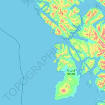
Name: Sealion Islands topographic map, elevation, terrain.
Location: Sealion Islands, Sitka, Alaska, United States (56.96369 -136.19830 57.60369 -135.55830)
Average elevation: 84 m
Minimum elevation: -7 m
Maximum elevation: 1,245 m
Thank you for supporting this site ❤️
Make a donation
Make a donation
Other topographic maps
Click on a map to view its topography, its elevation and its terrain.