
Make a donation
El Rehab topographic map
Click on the map to display elevation.
Make a donation
About this map
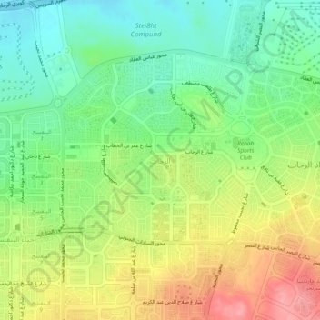
Name: El Rehab topographic map, elevation, terrain.
Location: El Rehab, Cairo, 11841, Egypt (30.04358 31.46899 30.08358 31.50899)
Average elevation: 240 m
Minimum elevation: 195 m
Maximum elevation: 301 m
Make a donation
Other topographic maps
Click on a map to view its topography, its elevation and its terrain.
Make a donation
Make a donation
Al Azhar Park
In 1984, Aga Khan IV was visiting Cairo on a conference. From his hotel balcony; Al-Darassa hill (Arabic: هضبة الدراسة) was visible: mounts of wreckage and ruins amassed during 500 years. He decided to intervene and offer that medieval area via the Historic Cities Support Programme the…
Average elevation: 53 m
Make a donation
Make a donation
Al Azhar Park
In 1984, Aga Khan IV was visiting Cairo on a conference. From his hotel balcony; Al-Darassa hill (Arabic: هضبة الدراسة) was visible: mounts of wreckage and ruins amassed during 500 years. He decided to intervene and offer that medieval area via the Historic Cities Support Programme the much-needed…
Average elevation: 53 m