
Thank you for supporting this site ❤️
Make a donation
Make a donation
Entre Deux Eaux topographic map
Click on the map to display elevation.
Thank you for supporting this site ❤️
Make a donation
Make a donation
About this map
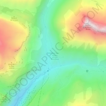
Name: Entre Deux Eaux topographic map, elevation, terrain.
Average elevation: 2,409 m
Minimum elevation: 1,940 m
Maximum elevation: 3,178 m
Thank you for supporting this site ❤️
Make a donation
Make a donation
Other topographic maps
Click on a map to view its topography, its elevation and its terrain.
Glacier de la Grande Motte
France > Auvergne-Rhône-Alpes > Savoie > Termignon
Average elevation: 2,976 m
Thank you for supporting this site ❤️
Make a donation
Make a donation