
Thank you for supporting this site ❤️
Make a donation
Make a donation
Crews topographic map
Click on the map to display elevation.
Thank you for supporting this site ❤️
Make a donation
Make a donation
About this map
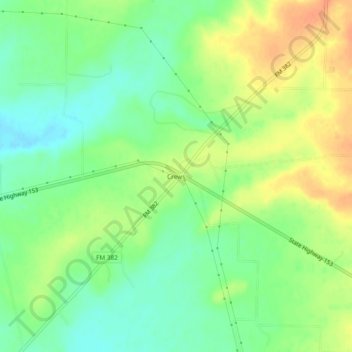
Name: Crews topographic map, elevation, terrain.
Location: Crews, Runnels County, Texas, United States (31.91487 -99.80092 31.95487 -99.76092)
Average elevation: 583 m
Minimum elevation: 564 m
Maximum elevation: 604 m
Thank you for supporting this site ❤️
Make a donation
Make a donation
Other topographic maps
Click on a map to view its topography, its elevation and its terrain.