
Amathole District Municipality topographic map
Interactive map
Click on the map to display elevation.
About this map
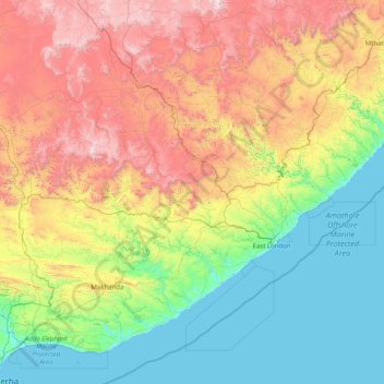
Name: Amathole District Municipality topographic map, elevation, terrain.
Location: Amathole District Municipality, Eastern Cape, South Africa (-33.49633 25.88731 -31.78706 29.09485)
Average elevation: 646 m
Minimum elevation: -1 m
Maximum elevation: 2,332 m
Other topographic maps
Click on a map to view its topography, its elevation and its terrain.
Lady Grey
South Africa > Eastern Cape > Joe Gqabi District Municipality > Senqu Local Municipality > Lady Grey
Lady Grey, Senqu Local Municipality, Joe Gqabi District Municipality, Eastern Cape, South Africa
Average elevation: 1,803 m