
Thank you for supporting this site ❤️
Make a donation
Make a donation
Wilson topographic map
Click on the map to display elevation.
Thank you for supporting this site ❤️
Make a donation
Make a donation
About this map
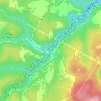
Name: Wilson topographic map, elevation, terrain.
Location: Wilson, Grant County, West Virginia, 27267, United States (39.23427 -79.41783 39.27427 -79.37783)
Average elevation: 824 m
Minimum elevation: 720 m
Maximum elevation: 976 m
Thank you for supporting this site ❤️
Make a donation
Make a donation
Other topographic maps
Click on a map to view its topography, its elevation and its terrain.