
Sarnen topographic map
Interactive map
Click on the map to display elevation.
About this map
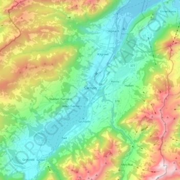
Name: Sarnen topographic map, elevation, terrain.
Location: Sarnen, Obwalden, Schweiz (46.85422 8.06700 46.93346 8.27766)
Average elevation: 1,040 m
Minimum elevation: 428 m
Maximum elevation: 2,354 m
Sarnen ist der Sitz der Kantonsschule Obwalden, des Berufs- und Weiterbildungszentrums Obwalden, der Höheren Fachschule Medizintechnik, der Schule Sarnen (Kindergarten, Primarschule und Sekundarschule/Integrierte Orientierungsschule), zweier Privatschulen und des Freizeitzentrums Obwalden.
Other topographic maps
Click on a map to view its topography, its elevation and its terrain.