
Thank you for supporting this site ❤️
Make a donation
Make a donation
Bühlertal topographic map
Click on the map to display elevation.
Thank you for supporting this site ❤️
Make a donation
Make a donation
Bühlertal
Bühlertal erstreckt sich über das Tal der Bühlot, welche hinter Bühl Sandbach heißt, und seine Nebentäler am Westhang des Nordschwarzwalds im Übergang zur Oberrheinischen Tiefebene in 190 bis 1000 Meter Höhe.
Thank you for supporting this site ❤️
Make a donation
Make a donation
About this map
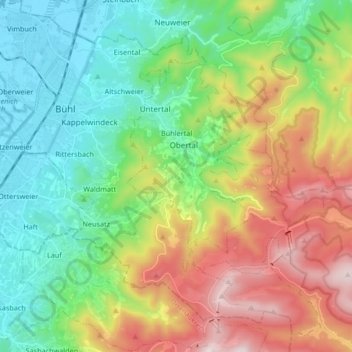
Name: Bühlertal topographic map, elevation, terrain.
Average elevation: 462 m
Minimum elevation: 126 m
Maximum elevation: 1,082 m
Thank you for supporting this site ❤️
Make a donation
Make a donation
Other topographic maps
Click on a map to view its topography, its elevation and its terrain.
Gausbach
Deutschland > Baden-Württemberg > Landkreis Rastatt > Forbach > Gausbach
Average elevation: 482 m