
Thank you for supporting this site ❤️
Make a donation
Make a donation
Riedern topographic map
Click on the map to display elevation.
Thank you for supporting this site ❤️
Make a donation
Make a donation
About this map
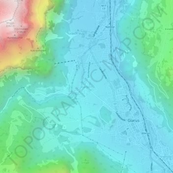
Name: Riedern topographic map, elevation, terrain.
Location: Riedern, Glarus, 8750, Schweiz (47.02995 9.03152 47.06995 9.07152)
Average elevation: 780 m
Minimum elevation: 451 m
Maximum elevation: 2,266 m
Thank you for supporting this site ❤️
Make a donation
Make a donation