
Make a donation
Wells topographic map
Click on the map to display elevation.
Make a donation
Wells
According to the United States Census Bureau, the town has a total area of 73.61 square miles (190.65 km2), of which, 57.55 square miles (149.05 km2) of it is land and 16.06 square miles (41.60 km2) is water.[1] Wells is drained by the Webhannet River. The highest point in town is an unnamed hill located a half mile south of the intersection of State Route 9 and Bragdon Road, which is 360 feet (110 m) above sea level. The lowest elevation is sea level, along the coastline with the Atlantic Ocean.
Make a donation
About this map
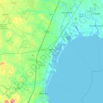
Name: Wells topographic map, elevation, terrain.
Location: Wells, York County, Maine, 04090, United States (43.24671 -70.72419 43.39123 -70.48721)
Average elevation: 28 m
Minimum elevation: -6 m
Maximum elevation: 153 m
Make a donation
Other topographic maps
Click on a map to view its topography, its elevation and its terrain.
Make a donation
Make a donation