
Krugzell topographic map
Interactive map
Click on the map to display elevation.
About this map
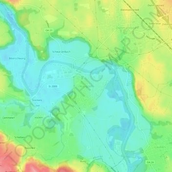
Name: Krugzell topographic map, elevation, terrain.
Average elevation: 670 m
Minimum elevation: 636 m
Maximum elevation: 735 m
Other topographic maps
Click on a map to view its topography, its elevation and its terrain.
Kalden
Deutschland > Bayern > Landkreis Oberallgäu > Altusried
Kalden, Altusried, Landkreis Oberallgäu, Bayern, 87452, Deutschland
Average elevation: 711 m
Kimratshofen
Deutschland > Bayern > Landkreis Oberallgäu > Altusried
Kimratshofen, Altusried, Landkreis Oberallgäu, Bayern, 87452, Deutschland
Average elevation: 770 m
Winneberg
Deutschland > Bayern > Landkreis Oberallgäu > Altusried
Winneberg, Altusried, Landkreis Oberallgäu, Bayern, 87452, Deutschland
Average elevation: 755 m
Weihalden
Deutschland > Bayern > Landkreis Oberallgäu > Altusried
Weihalden, Altusried, Landkreis Oberallgäu, Bayern, 87452, Deutschland
Average elevation: 735 m
Lausers
Deutschland > Bayern > Landkreis Oberallgäu > Altusried
Lausers, Altusried, Landkreis Oberallgäu, Bayern, 87452, Deutschland
Average elevation: 766 m
Wolfen
Deutschland > Bayern > Landkreis Oberallgäu > Altusried
Wolfen, Altusried, Landkreis Oberallgäu, Bayern, 87487, Deutschland
Average elevation: 731 m