
Thank you for supporting this site ❤️
Make a donation
Make a donation
Severna Park topographic map
Click on the map to display elevation.
Thank you for supporting this site ❤️
Make a donation
Make a donation
About this map
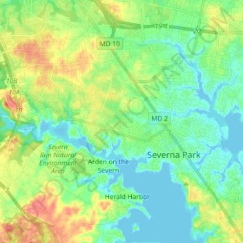
Name: Severna Park topographic map, elevation, terrain.
Location: Severna Park, Anne Arundel County, Maryland, United States (39.04052 -76.63290 39.12611 -76.50832)
Average elevation: 20 m
Minimum elevation: -3 m
Maximum elevation: 61 m
Thank you for supporting this site ❤️
Make a donation
Make a donation
Other topographic maps
Click on a map to view its topography, its elevation and its terrain.
Lower Magothy Beach
United States > Maryland > Anne Arundel County > Severna Park > Lower Magothy Beach
Average elevation: 9 m
Windrush Farm
United States > Maryland > Anne Arundel County > Severna Park > Windrush Farm
Average elevation: 10 m
Thank you for supporting this site ❤️
Make a donation
Make a donation
Severndale
United States > Maryland > Anne Arundel County > Severna Park > Severndale
Average elevation: 18 m
Linstead-on-the-Severn
United States > Maryland > Anne Arundel County > Severna Park
Average elevation: 11 m