
Thank you for supporting this site ❤️
Make a donation
Make a donation
Galena topographic map
Click on the map to display elevation.
Thank you for supporting this site ❤️
Make a donation
Make a donation
About this map
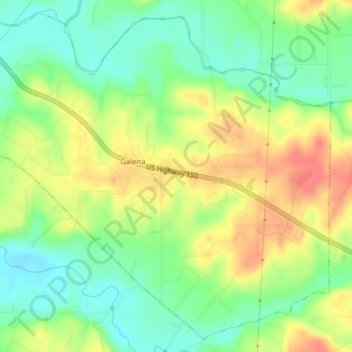
Name: Galena topographic map, elevation, terrain.
Location: Galena, Floyd County, Indiana, United States (38.33619 -85.95879 38.36460 -85.91958)
Average elevation: 232 m
Minimum elevation: 204 m
Maximum elevation: 266 m
Thank you for supporting this site ❤️
Make a donation
Make a donation
Other topographic maps
Click on a map to view its topography, its elevation and its terrain.