
Thank you for supporting this site ❤️
Make a donation
Make a donation
O'Brion topographic map
Click on the map to display elevation.
Thank you for supporting this site ❤️
Make a donation
Make a donation
About this map
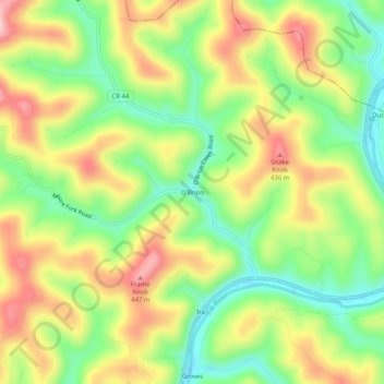
Name: O'Brion topographic map, elevation, terrain.
Location: O'Brion, Clay County, West Virginia, 25063, United States (38.55538 -80.98177 38.59538 -80.94177)
Average elevation: 331 m
Minimum elevation: 223 m
Maximum elevation: 457 m
Thank you for supporting this site ❤️
Make a donation
Make a donation
Other topographic maps
Click on a map to view its topography, its elevation and its terrain.
Clay
United States > West Virginia > Clay County
The city of Charleston, the state capitol, is approximately 40 miles (64 km) from Clay to the southwest. Clay is centrally located within Clay County at 38°27′46″N 81°4′48″W / 38.46278°N 81.08000°W / 38.46278; -81.08000 (38.462855, -81.080024), along the Elk River and West Virginia Route…
Average elevation: 312 m