
Thank you for supporting this site ❤️
Make a donation
Make a donation
Liberty Hill topographic map
Click on the map to display elevation.
Thank you for supporting this site ❤️
Make a donation
Make a donation
About this map
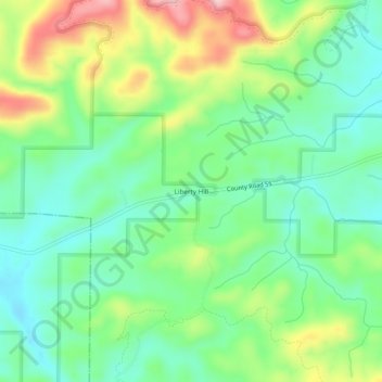
Name: Liberty Hill topographic map, elevation, terrain.
Location: Liberty Hill, Cleburne County, Alabama, United States (33.82871 -85.59274 33.86871 -85.55274)
Average elevation: 313 m
Minimum elevation: 247 m
Maximum elevation: 437 m
Thank you for supporting this site ❤️
Make a donation
Make a donation
Other topographic maps
Click on a map to view its topography, its elevation and its terrain.