
Thank you for supporting this site ❤️
Make a donation
Make a donation
Municipio de La Paz topographic map
Click on the map to display elevation.
Thank you for supporting this site ❤️
Make a donation
Make a donation
About this map
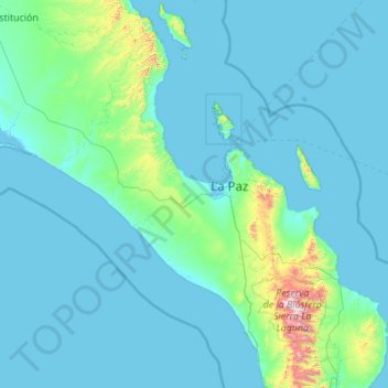
Name: Municipio de La Paz topographic map, elevation, terrain.
Location: Municipio de La Paz, Baja California Sur, Mexico (23.11403 -111.82083 25.11554 -109.69483)
Average elevation: 106 m
Minimum elevation: -1 m
Maximum elevation: 2,021 m
Thank you for supporting this site ❤️
Make a donation
Make a donation
Other topographic maps
Click on a map to view its topography, its elevation and its terrain.
Loreto
Mexico > Baja California Sur > Municipio de Loreto
Loreto is located on the east coast of the Baja California Peninsula, at 26º00'46" N 111º20'36" W. It is bordered on the east by the Gulf of California, on the west by the Transpeninsular Highway, and on the south by the Arroyo Loreto, a dry creek bed that only fills with water after a heavy rainfall. The…
Average elevation: 22 m
Thank you for supporting this site ❤️
Make a donation
Make a donation