
Thank you for supporting this site ❤️
Make a donation
Make a donation
Le Moulin topographic map
Click on the map to display elevation.
Thank you for supporting this site ❤️
Make a donation
Make a donation
About this map
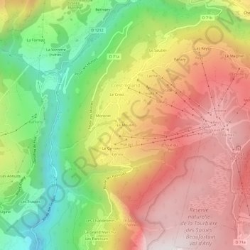
Name: Le Moulin topographic map, elevation, terrain.
Average elevation: 1,182 m
Minimum elevation: 619 m
Maximum elevation: 1,695 m
Thank you for supporting this site ❤️
Make a donation
Make a donation
Other topographic maps
Click on a map to view its topography, its elevation and its terrain.
Réserve naturelle de la Tourbière des Saisies - Beaufortain - Val d'Arly
France > Auvergne-Rhône-Alpes > Savoie > Crest-Voland
Average elevation: 1,559 m