
丽江市 topographic map
Interactive map
Click on the map to display elevation.
About this map
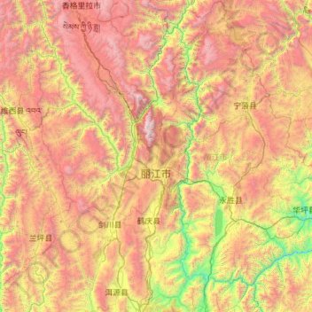
Name: 丽江市 topographic map, elevation, terrain.
Location: 丽江市, 云南省, 中国 (25.98858 99.38218 27.92759 101.51230)
Average elevation: 2,735 m
Minimum elevation: 1,096 m
Maximum elevation: 5,476 m
丽江处于青藏高原与云贵高原的衔接地段,市区古城区在丽江坝子(或丽江坝区)内。丽江地貌多样,有雪山、草甸等自然景观,且因丽江各地地形状况和热力状况迥异,故该市各区域小气候十分显著。
Other topographic maps
Click on a map to view its topography, its elevation and its terrain.
西双版纳热带植物园-百竹园
西双版纳热带植物园-百竹园, 勐仑镇, 勐腊县, 西双版纳傣族自治州, 云南省, 666100, 中国
Average elevation: 559 m