
Thank you for supporting this site ❤️
Make a donation
Make a donation
Whaletown topographic map
Click on the map to display elevation.
Thank you for supporting this site ❤️
Make a donation
Make a donation
About this map
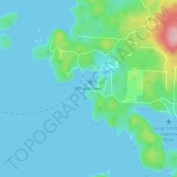
Name: Whaletown topographic map, elevation, terrain.
Average elevation: 26 m
Minimum elevation: -2 m
Maximum elevation: 175 m
Thank you for supporting this site ❤️
Make a donation
Make a donation
Other topographic maps
Click on a map to view its topography, its elevation and its terrain.
Protection Island
Canada > British Columbia > Strathcona Regional District > Area C (Cortes Island)
Average elevation: 36 m
Cortes Island
Canada > British Columbia > Strathcona Regional District > Area C (Cortes Island)
Average elevation: 72 m