
Thank you for supporting this site ❤️
Make a donation
Make a donation
Town of Ripley topographic map
Click on the map to display elevation.
Thank you for supporting this site ❤️
Make a donation
Make a donation
About this map
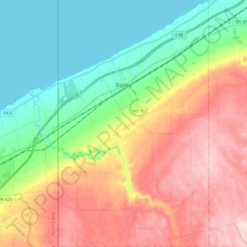
Name: Town of Ripley topographic map, elevation, terrain.
Average elevation: 325 m
Minimum elevation: 171 m
Maximum elevation: 541 m
Thank you for supporting this site ❤️
Make a donation
Make a donation
Other topographic maps
Click on a map to view its topography, its elevation and its terrain.
Thank you for supporting this site ❤️
Make a donation
Make a donation
Cowdens Corner
United States > New York > Chautauqua County > Town of Arkwright
Average elevation: 389 m