
Make a donation
Preiss Heights topographic map
Click on the map to display elevation.
Make a donation
About this map
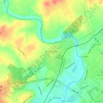
Name: Preiss Heights topographic map, elevation, terrain.
Location: Preiss Heights, Comal County, Texas, 78135, United States (29.72050 -98.13918 29.76050 -98.09918)
Average elevation: 214 m
Minimum elevation: 185 m
Maximum elevation: 251 m
Make a donation
Other topographic maps
Click on a map to view its topography, its elevation and its terrain.
New Braunfels
United States > Texas > Comal County
New Braunfels occupies a transitional Hill Country setting on the Balcones Escarpment, where the higher, more dissected limestone uplands of the Edwards Plateau give way southeastward toward lower prairie terrain. The city’s relief is organized around the Guadalupe River valley and the short spring-fed Comal…
Average elevation: 228 m
Make a donation
New Braunfels
United States > Texas > Comal County
New Braunfels occupies a transitional Hill Country setting on the Balcones Escarpment, where the higher, more dissected limestone uplands of the Edwards Plateau give way southeastward toward lower prairie terrain. The city’s relief is organized around the Guadalupe River valley and the short spring-fed Comal…
Average elevation: 228 m
Comal River
United States > Texas > Comal County > New Braunfels > Landa Park Estates
Average elevation: 206 m
Make a donation