
Make a donation
Bucharest topographic map
Click on the map to display elevation.
Make a donation
Bucharest
The city has an area of 226 km2 (87 sq mi). The altitude varies from 55.8 m (183.1 ft) at the Dâmbovița bridge in Cățelu, southeastern Bucharest and 91.5 m (300.2 ft) at the Militari church. The city has a roughly round shape, with the centre situated in the cross-way of the main north–south/east-west axes at University Square. The milestone for Romania's Kilometre Zero is placed just south of University Square in front of the New St. George Church (Sfântul Gheorghe Nou) at St. George Square (Piața Sfântul Gheorghe). Bucharest's radius, from University Square to the city limits in all directions, varies from 10 to 12 km (6 to 7 mi).
Make a donation
About this map
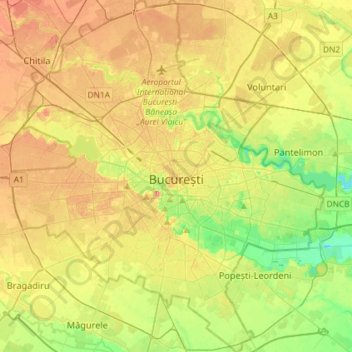
Name: Bucharest topographic map, elevation, terrain.
Location: Bucharest, Romania (44.33425 25.96667 44.54140 26.22558)
Average elevation: 82 m
Minimum elevation: 49 m
Maximum elevation: 117 m
Make a donation