
Thank you for supporting this site ❤️
Make a donation
Make a donation
Brüggen topographic map
Click on the map to display elevation.
Thank you for supporting this site ❤️
Make a donation
Make a donation
About this map
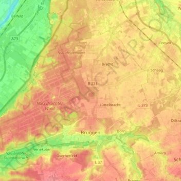
Name: Brüggen topographic map, elevation, terrain.
Location: Brüggen, Kreis Viersen, Nordrhein-Westfalen, 41379, Deutschland (51.22732 6.07265 51.30745 6.24146)
Average elevation: 49 m
Minimum elevation: 9 m
Maximum elevation: 74 m
Thank you for supporting this site ❤️
Make a donation
Make a donation
Other topographic maps
Click on a map to view its topography, its elevation and its terrain.
Oberkrüchten
Deutschland > Nordrhein-Westfalen > Kreis Viersen > Niederkrüchten
Average elevation: 67 m
Thank you for supporting this site ❤️
Make a donation
Make a donation