
Thank you for supporting this site ❤️
Make a donation
Make a donation
Bleibeskopf topographic map
Click on the map to display elevation.
Thank you for supporting this site ❤️
Make a donation
Make a donation
About this map
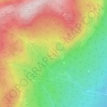
Name: Bleibeskopf topographic map, elevation, terrain.
Average elevation: 454 m
Minimum elevation: 276 m
Maximum elevation: 636 m
Thank you for supporting this site ❤️
Make a donation
Make a donation
Other topographic maps
Click on a map to view its topography, its elevation and its terrain.
Ober-Eschbach
Deutschland > Hessen > Hochtaunuskreis > Bad Homburg vor der Höhe
Ober-Eschbach ist ein Stadtteil von Bad Homburg vor der Höhe im südhessischen Hochtaunuskreis.
Average elevation: 187 m
Dornholzhausen
Deutschland > Hessen > Hochtaunuskreis > Bad Homburg vor der Höhe
Average elevation: 361 m
Thank you for supporting this site ❤️
Make a donation
Make a donation