
Thank you for supporting this site ❤️
Make a donation
Make a donation
Barnesville topographic map
Click on the map to display elevation.
Thank you for supporting this site ❤️
Make a donation
Make a donation
About this map
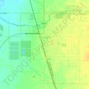
Name: Barnesville topographic map, elevation, terrain.
Location: Barnesville, Clay County, Minnesota, 56514, United States (46.63790 -96.43583 46.66208 -96.39578)
Average elevation: 311 m
Minimum elevation: 297 m
Maximum elevation: 322 m
Thank you for supporting this site ❤️
Make a donation
Make a donation
Other topographic maps
Click on a map to view its topography, its elevation and its terrain.
Thank you for supporting this site ❤️
Make a donation
Make a donation
confluence of Red River of the North and Buffalo River
United States > Minnesota > Clay County
Average elevation: 268 m