
Thank you for supporting this site ❤️
Make a donation
Make a donation
Morrinsville topographic map
Click on the map to display elevation.
Thank you for supporting this site ❤️
Make a donation
Make a donation
About this map
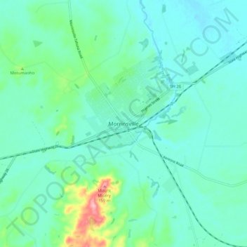
Name: Morrinsville topographic map, elevation, terrain.
Average elevation: 39 m
Minimum elevation: 10 m
Maximum elevation: 164 m
Thank you for supporting this site ❤️
Make a donation
Make a donation
Other topographic maps
Click on a map to view its topography, its elevation and its terrain.
Hapuakohe Range / Te Hapū-a-Kohe
New Zealand > Waikato > Matamata Piako District
Average elevation: 120 m