
Thank you for supporting this site ❤️
Make a donation
Make a donation
Ilchester topographic map
Click on the map to display elevation.
Thank you for supporting this site ❤️
Make a donation
Make a donation
About this map
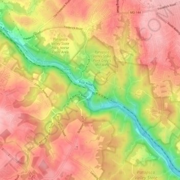
Name: Ilchester topographic map, elevation, terrain.
Location: Ilchester, Howard County, Maryland, 21052, United States (39.23094 -76.78469 39.27094 -76.74469)
Average elevation: 107 m
Minimum elevation: 12 m
Maximum elevation: 161 m
Thank you for supporting this site ❤️
Make a donation
Make a donation
Other topographic maps
Click on a map to view its topography, its elevation and its terrain.
Patapsco Valley State Park
United States > Maryland > Howard County > Ilchester
Average elevation: 131 m