
Thank you for supporting this site ❤️
Make a donation
Make a donation
San Onofre topographic map
Click on the map to display elevation.
Thank you for supporting this site ❤️
Make a donation
Make a donation
About this map
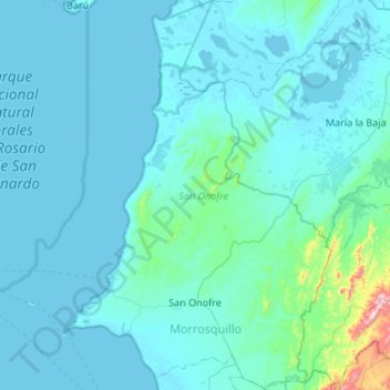
Name: San Onofre topographic map, elevation, terrain.
Location: San Onofre, Morrosquillo, Sucre, Colombia (9.61985 -75.70377 10.14849 -75.33655)
Average elevation: 40 m
Minimum elevation: -3 m
Maximum elevation: 691 m
Thank you for supporting this site ❤️
Make a donation
Make a donation
Other topographic maps
Click on a map to view its topography, its elevation and its terrain.