
Thank you for supporting this site ❤️
Make a donation
Make a donation
Wetter (Ruhr) topographic map
Click on the map to display elevation.
Thank you for supporting this site ❤️
Make a donation
Make a donation
About this map
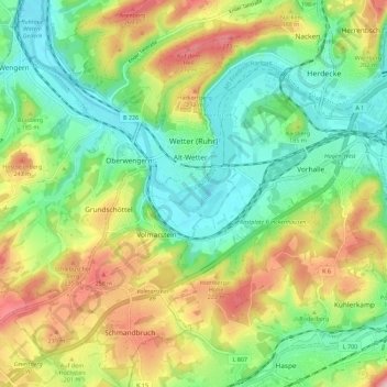
Name: Wetter (Ruhr) topographic map, elevation, terrain.
Average elevation: 161 m
Minimum elevation: 77 m
Maximum elevation: 301 m
Thank you for supporting this site ❤️
Make a donation
Make a donation
Other topographic maps
Click on a map to view its topography, its elevation and its terrain.
Oberbredenscheid
Germany > North Rhine-Westphalia > Ennepe-Ruhr-Kreis > Hattingen > Oberbredenscheid
Average elevation: 153 m