
Thank you for supporting this site ❤️
Make a donation
Make a donation
Sainte-Catherine topographic map
Click on the map to display elevation.
Thank you for supporting this site ❤️
Make a donation
Make a donation
Sainte-Catherine
Sainte Catherine est une commune française située à 680 m d’altitude dans le département du Rhône, en région Auvergne-Rhone-Alpes.
Thank you for supporting this site ❤️
Make a donation
Make a donation
About this map
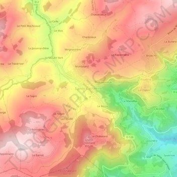
Name: Sainte-Catherine topographic map, elevation, terrain.
Average elevation: 723 m
Minimum elevation: 430 m
Maximum elevation: 904 m
Thank you for supporting this site ❤️
Make a donation
Make a donation