
Thank you for supporting this site ❤️
Make a donation
Make a donation
Strawberry Point topographic map
Click on the map to display elevation.
Thank you for supporting this site ❤️
Make a donation
Make a donation
About this map
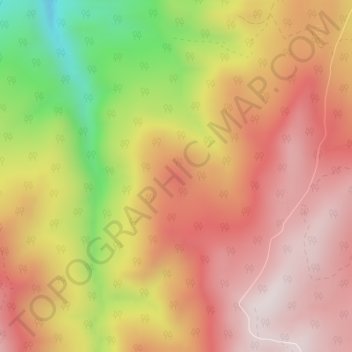
Name: Strawberry Point topographic map, elevation, terrain.
Location: Strawberry Point, Iron County, Utah, 84772, United States (37.75104 -112.94305 37.75114 -112.94295)
Average elevation: 2,436 m
Minimum elevation: 2,031 m
Maximum elevation: 2,690 m
Thank you for supporting this site ❤️
Make a donation
Make a donation
Other topographic maps
Click on a map to view its topography, its elevation and its terrain.