
Thank you for supporting this site ❤️
Make a donation
Make a donation
Hartsville topographic map
Click on the map to display elevation.
Thank you for supporting this site ❤️
Make a donation
Make a donation
About this map
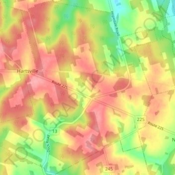
Name: Hartsville topographic map, elevation, terrain.
Location: Hartsville, Queens County, Prince Edward Island, Canada (46.29203 -63.41166 46.33883 -63.34543)
Average elevation: 90 m
Minimum elevation: 31 m
Maximum elevation: 132 m
Thank you for supporting this site ❤️
Make a donation
Make a donation
Other topographic maps
Click on a map to view its topography, its elevation and its terrain.