
Thank you for supporting this site ❤️
Make a donation
Make a donation
Bismarck topographic map
Click on the map to display elevation.
Thank you for supporting this site ❤️
Make a donation
Make a donation
About this map
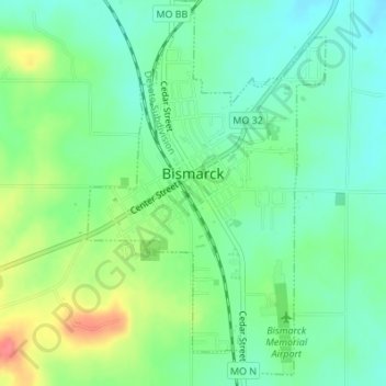
Name: Bismarck topographic map, elevation, terrain.
Location: Bismarck, St. Francois County, Missouri, United States (37.75512 -90.63420 37.78062 -90.61309)
Average elevation: 314 m
Minimum elevation: 291 m
Maximum elevation: 359 m
Thank you for supporting this site ❤️
Make a donation
Make a donation
Other topographic maps
Click on a map to view its topography, its elevation and its terrain.
Thank you for supporting this site ❤️
Make a donation
Make a donation
Bonne Terre
United States > Missouri > St. Francois County > Bonne Terre > Bonne Terre
Average elevation: 239 m