
Thank you for supporting this site ❤️
Make a donation
Make a donation
Erpfting topographic map
Click on the map to display elevation.
Thank you for supporting this site ❤️
Make a donation
Make a donation
About this map
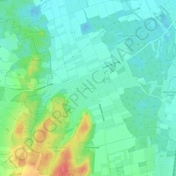
Name: Erpfting topographic map, elevation, terrain.
Average elevation: 628 m
Minimum elevation: 605 m
Maximum elevation: 688 m
Thank you for supporting this site ❤️
Make a donation
Make a donation
Other topographic maps
Click on a map to view its topography, its elevation and its terrain.
86899
Deutschland > Bayern > Landkreis Landsberg am Lech > Landsberg am Lech > Friedheim
Average elevation: 626 m
Lech
Deutschland > Bayern > Landkreis Landsberg am Lech > Landsberg am Lech > Pitzling
Average elevation: 615 m