
Thank you for supporting this site ❤️
Make a donation
Make a donation
Parkville topographic map
Click on the map to display elevation.
Thank you for supporting this site ❤️
Make a donation
Make a donation
About this map
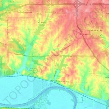
Name: Parkville topographic map, elevation, terrain.
Location: Parkville, Platte County, Missouri, 64152, United States (39.16925 -94.77052 39.25437 -94.65206)
Average elevation: 273 m
Minimum elevation: 222 m
Maximum elevation: 328 m
Thank you for supporting this site ❤️
Make a donation
Make a donation
Other topographic maps
Click on a map to view its topography, its elevation and its terrain.