
Thank you for supporting this site ❤️
Make a donation
Make a donation
Heirweg topographic map
Click on the map to display elevation.
Thank you for supporting this site ❤️
Make a donation
Make a donation
About this map
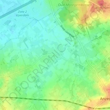
Name: Heirweg topographic map, elevation, terrain.
Location: Heirweg, Anzegem, Kortrijk, West-Vlaanderen, 8570, België (50.82838 3.42743 50.86838 3.46743)
Average elevation: 27 m
Minimum elevation: 9 m
Maximum elevation: 65 m
Thank you for supporting this site ❤️
Make a donation
Make a donation
Other topographic maps
Click on a map to view its topography, its elevation and its terrain.
Ingooigem
België > West-Vlaanderen > Kortrijk > Anzegem
Ingooigem ligt in Zandlemig Vlaanderen op een hoogte van 35-62 meter. Op het grondgebied loopt de Tjampensbeek en de beek Beek te Biest.
Average elevation: 31 m