
Make a donation
Los Monegros topographic map
Click on the map to display elevation.
Make a donation
Los Monegros
The Sierra de Alcubierre mountain chain crosses the comarca from Northwest to Southeast. Its maximum elevation is 822 meters, at the mountain called Oscuro. The climate is semiarid, with scarce rainfall and high temperatures in the autumn. The area has numerous saltwater and freshwater lakes, including the Lake of Sariñena and the Lake of la Playa.
Make a donation
About this map
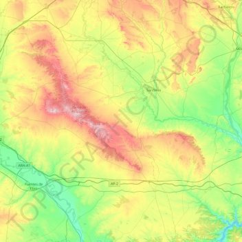
Name: Los Monegros topographic map, elevation, terrain.
Location: Los Monegros, Huesca, Aragon, Spain (41.34781 -0.72843 42.05641 0.04176)
Average elevation: 351 m
Minimum elevation: 108 m
Maximum elevation: 813 m
Make a donation
Other topographic maps
Click on a map to view its topography, its elevation and its terrain.
"El Cerro la Silla" (Cima oeste)
Spain > Aragon > Campo de Cariñena > Cosuenda
Average elevation: 954 m
Make a donation
Make a donation
Make a donation
Make a donation
Make a donation
Make a donation
Marcuello
Spain > Aragon > Hoya de Huesca / Plana de Uesca > Loarre > Linás de Marcuello
Average elevation: 863 m
Make a donation
Sosas
Spain > Aragon > Somontano de Barbastro > Hoz y Costeán > Hoz de Barbastro
Average elevation: 601 m
Make a donation
"El Cerro la Silla" (Cima oeste)
Spain > Aragon > Campo de Cariñena > Cosuenda
Average elevation: 954 m
Make a donation
Sistema Ibérico
Spain > Aragon > Tarazona y el Moncayo > Tarazona
The geology of the Iberian System is complex, for it can hardly be defined as a homogeneous system. It is composed of a haphazard and motley series of mountain ranges, massifs, plateaus and depressions without a definite common petrologic composition and overall structure. Nummulite limestone, marble and…
Average elevation: 1,906 m
Make a donation
Vitales
Spain > Aragon > Hoya de Huesca / Plana de Uesca > Monflorite-Lascasas
Average elevation: 492 m
Make a donation
Pla de Beronia
Spain > Aragon > Bajo Aragón-Caspe / Baix Aragó-Casp > Fabara / Favara
Average elevation: 215 m
Make a donation
Riglos
Spain > Aragon > Hoya de Huesca / Plana de Uesca > Las Peñas de Riglos
Average elevation: 726 m
Make a donation
Huesca
Huesca lies on a plateau in the northern region of Aragón, with an elevation of 488 m (1,601.05 ft) above sea level. Close to the city lie the Sierra de Guara mountains, which reach 2,077 m. The geographical coordinates of the city are: 42° 08´ N, 0° 24´ W.
Average elevation: 589 m
Make a donation
Make a donation
Make a donation
Make a donation