
Thank you for supporting this site ❤️
Make a donation
Make a donation
Grube topographic map
Click on the map to display elevation.
Thank you for supporting this site ❤️
Make a donation
Make a donation
About this map
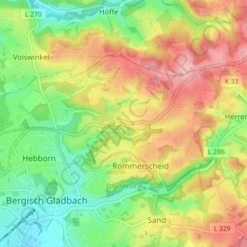
Name: Grube topographic map, elevation, terrain.
Average elevation: 151 m
Minimum elevation: 81 m
Maximum elevation: 233 m
Thank you for supporting this site ❤️
Make a donation
Make a donation
Other topographic maps
Click on a map to view its topography, its elevation and its terrain.
Kradepohlsmühle
Deutschland > Nordrhein-Westfalen > Rheinisch-Bergischer Kreis > Bergisch Gladbach > Kradepohlsmühle
Average elevation: 80 m
51427
Deutschland > Nordrhein-Westfalen > Rheinisch-Bergischer Kreis > Bergisch Gladbach
Average elevation: 125 m