
Make a donation
Shah Alam topographic map
Click on the map to display elevation.
Make a donation
Shah Alam
Located in Klang Valley, Shah Alam topography is mostly flat, except in the northern part of the city where it features a prominent rolling hill.
Make a donation
About this map
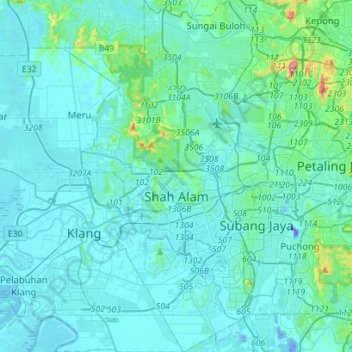
Name: Shah Alam topographic map, elevation, terrain.
Location: Shah Alam, Petaling, Selangor, Malaysia (2.94962 101.42773 3.22972 101.59139)
Average elevation: 28 m
Minimum elevation: -42 m
Maximum elevation: 324 m
Make a donation
Other topographic maps
Click on a map to view its topography, its elevation and its terrain.
Make a donation
Kampung Indian Settlement Batu Caves
Malaysia > Selangor > Selayang Municipal Council > Batu Caves
Average elevation: 68 m
Make a donation
Make a donation
Make a donation
Make a donation
Make a donation
Make a donation
Make a donation
Make a donation
Make a donation
Make a donation
Make a donation
Make a donation
Kampung Indian Settlement Batu Caves
Malaysia > Selangor > Selayang Municipal Council > Batu Caves
Average elevation: 68 m
Make a donation
Kampung Sri Gombak Indah
Malaysia > Selangor > Selayang Municipal Council > Batu Caves
Average elevation: 84 m
Make a donation
Make a donation
Make a donation
Sungai Haji Dorani
Malaysia > Selangor > Kampung Sungai Haji Dorani > Kampung Nelayan Sungai Haji Durani
Average elevation: 3 m
Kampung Melayu Pekan Rawang
Malaysia > Selangor > Selayang Municipal Council > Rawang
Average elevation: 48 m
Make a donation
Make a donation
Make a donation
Make a donation
Selayang
Malaysia > Selangor > Selayang
Given its varied topography pattern and close proximity to the Titiwangsa Mountains (Banjaran Titiwangsa), Selayang is a mix of urban and countryside sceneries. Its premier natural attraction, which is well-known across the country, is the Forest Research Institute Malaysia (FRIM), also known as FRIM Kepong.…
Average elevation: 201 m
Make a donation
Make a donation
Make a donation
Kampung Gombak Utara
Malaysia > Selangor > Selayang Municipal Council > Gombak
Average elevation: 121 m
Make a donation