
Make a donation
Netherlands topographic map
Click on the map to display elevation.
Make a donation
Netherlands
Netherlands literally means "lower countries" in reference to its low elevation and flat topography, with only about 50% of its land exceeding 1 m (3.3 ft) above sea level, and nearly 26% falling below sea level. Most of the areas below sea level, known as polders, are the result of land reclamation that began in the 14th century. Colloquially or informally the Netherlands is occasionally referred to by the pars pro toto Holland. With a population of 17.5 million people, all living within a total area of roughly 41,800 km2 (16,100 sq mi)—of which the land area is 33,500 km2 (12,900 sq mi)—the Netherlands is the 16th most densely populated country in the world and the second-most densely populated country in the European Union, with a density of 523 people per square kilometre (1,350 people/sq mi). Nevertheless, it is the world's second-largest exporter of food and agricultural products by value, owing to its fertile soil, mild climate, intensive agriculture, and inventiveness.
Make a donation
About this map
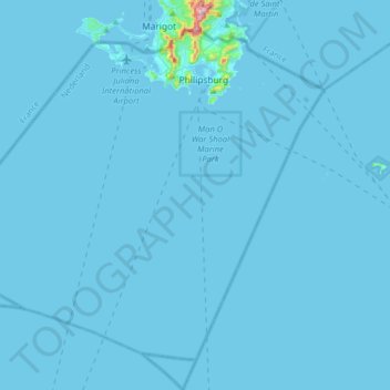
Name: Netherlands topographic map, elevation, terrain.
Location: Country of Sint Maarten, Netherlands (17.80621 -63.26779 18.06399 -62.94945)
Average elevation: 4 m
Minimum elevation: -2 m
Maximum elevation: 408 m
Make a donation
Other topographic maps
Click on a map to view its topography, its elevation and its terrain.