
Make a donation
Sierra City topographic map
Click on the map to display elevation.
Make a donation
Sierra City
Sierra City (Sierra, Spanish for "mountain range") is a census-designated place in Sierra County, California, United States. The elevation of Sierra City is 4,147 feet (1,264 m), and the town is situated in the canyon of the North Yuba River on California State Route 49, twelve miles northeast of the county seat of Sierra County, Downieville. The population was 221 at the 2010 census.
Make a donation
About this map
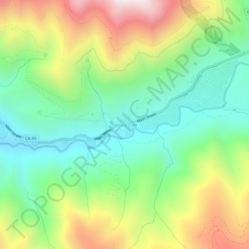
Name: Sierra City topographic map, elevation, terrain.
Location: Sierra City, Sierra County, California, United States (39.54555 -120.65600 39.58555 -120.61600)
Average elevation: 1,608 m
Minimum elevation: 1,191 m
Maximum elevation: 2,299 m
Make a donation
Other topographic maps
Click on a map to view its topography, its elevation and its terrain.
Loyalton
United States > California > Sierra County
Loyalton is located at 39°40′36″N 120°14′35″W / 39.67667°N 120.24306°W / 39.67667; -120.24306 (39.676558, -120.243157). Elevation above mean sea level for the area was listed as roughly 4,930 feet (1,500 m). The city is located along California State Route 49, the Gold Country Highway.
Average elevation: 1,514 m