
Spingfield topographic map
Interactive map
Click on the map to display elevation.
About this map
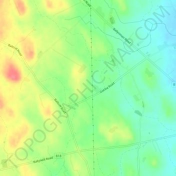
Name: Spingfield topographic map, elevation, terrain.
Average elevation: 55 m
Minimum elevation: 27 m
Maximum elevation: 95 m
Other topographic maps
Click on a map to view its topography, its elevation and its terrain.
River Ness
Verenigd Koninkrijk > Noord-Ierland > County Londonderry > Derry/Londonderry
River Ness, Derry/Londonderry, County Londonderry, Noord-Ierland, BT47 3EY, Verenigd Koninkrijk
Average elevation: 120 m
Londonderry/Derry
Verenigd Koninkrijk > Noord-Ierland > County Londonderry
Londonderry/Derry, County Londonderry, Ulster, Noord-Ierland, BT48 6BU, Verenigd Koninkrijk
Average elevation: 88 m