
Trujillo Alto topographic map
Interactive map
Click on the map to display elevation.
About this map
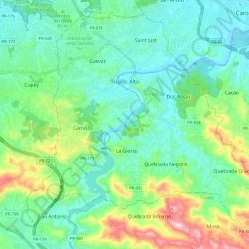
Name: Trujillo Alto topographic map, elevation, terrain.
Location: Trujillo Alto, Puerto Rico, United States (18.29328 -66.04131 18.38084 -65.93888)
Average elevation: 102 m
Minimum elevation: -3 m
Maximum elevation: 381 m
Other topographic maps
Click on a map to view its topography, its elevation and its terrain.
Bird Sanctuary
United States > Puerto Rico > Río Grande > Río Grande
Bird Sanctuary, Herreras, Río Grande, Puerto Rico, United States
Average elevation: 2 m