
Thank you for supporting this site ❤️
Make a donation
Make a donation
Tiffin topographic map
Click on the map to display elevation.
Thank you for supporting this site ❤️
Make a donation
Make a donation
About this map
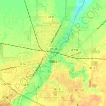
Name: Tiffin topographic map, elevation, terrain.
Location: Tiffin, Seneca County, Ohio, 44883, United States (41.08056 -83.22531 41.14587 -83.14960)
Average elevation: 235 m
Minimum elevation: 213 m
Maximum elevation: 248 m
Thank you for supporting this site ❤️
Make a donation
Make a donation
Other topographic maps
Click on a map to view its topography, its elevation and its terrain.