
Make a donation
Mount Kanlaon topographic map
Click on the map to display elevation.
Make a donation
Mount Kanlaon
Kanlaon, also known as Mount Kanlaon and Kanlaon Volcano (Hiligaynon: Bolkang Kanglaon; Cebuano: Bolkang Kanglaon; Filipino: Bulkang Kanlaon), is an active stratovolcano and the highest mountain on the island of Negros in the Philippines, as well as the highest point in the Visayas, with an elevation of 2,465 m (8,087 ft) above sea level. Mount Kanlaon ranks as the 42nd-highest peak of an island in the world.
Make a donation
About this map
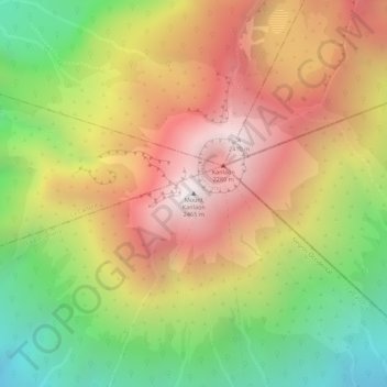
Name: Mount Kanlaon topographic map, elevation, terrain.
Average elevation: 1,920 m
Minimum elevation: 1,322 m
Maximum elevation: 2,430 m
Make a donation
Other topographic maps
Click on a map to view its topography, its elevation and its terrain.
Candoni
Philippines > Negros Occidental
Candoni is located 130 kilometres (81 mi) south-south-west of the provincial capital, Bacolod. It is approximately four hour drive from Bacolod City aboard a public utility vehicle and about two hours and 45 minutes on a private car. From Bacolod City, buses are available at Bacolod South Terminal. From…
Average elevation: 308 m
Make a donation
Make a donation